Ibike
USA/Canada Program
Rolling the Islands of the Salish Sea
Photo essay: Rolling the Islands of the Salish Sea: Lopez Island and San Juan Island
Swinomish to FRIDAY HARBOR (25km, 15mi). Learn about the revival of
traditional culture, and a beautiful ferry ride.
Points of interest: Anacortes, Mt. Baker, Lopez Is, Shaw Is.,
Orcas Is, Mt Constitution, English Camp (Lummi
winter village), Lime Kiln, Whale Watching Point and American Camp.

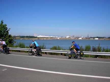 On
the out-skirts of Anacortes is the Marsh Point oil refinery, one of the major
oil refineries in Washington State. Our
carbon-free, non-petroleum economy whizzes by the petroleum economy -- well that
is a little myopic because it means you are ignoring all of the petroleum
economy cars whizzing by us on the other side. So, I guess you can say our
carbon-free economy slides between the petroleum economy.
On
the out-skirts of Anacortes is the Marsh Point oil refinery, one of the major
oil refineries in Washington State. Our
carbon-free, non-petroleum economy whizzes by the petroleum economy -- well that
is a little myopic because it means you are ignoring all of the petroleum
economy cars whizzing by us on the other side. So, I guess you can say our
carbon-free economy slides between the petroleum economy. Ironically
the oil refinery is encircled by bike routes and an old railroad trestle that
runs between Anacortes and March Point has
been converted to a non-motorized Tommy Thompson Trail (right).
Ironically
the oil refinery is encircled by bike routes and an old railroad trestle that
runs between Anacortes and March Point has
been converted to a non-motorized Tommy Thompson Trail (right).

 Anacortes
has a limited number of grand older building so it is one of those
towns that is keeping it history alive by installing murals around the city.
We posed with this inanimate group at the hardware store trying out a bicycle
built for two. Most of the murals depicted scenes of life in the town in
the late 1800's or early 1900's. The hardware store, itself, is a bit of a
museum from the era before "hardware" had
Anacortes
has a limited number of grand older building so it is one of those
towns that is keeping it history alive by installing murals around the city.
We posed with this inanimate group at the hardware store trying out a bicycle
built for two. Most of the murals depicted scenes of life in the town in
the late 1800's or early 1900's. The hardware store, itself, is a bit of a
museum from the era before "hardware" had any reference to computers.
It is filled with tools and supplies for wood working, metal working,
construction, electrical, plumbing, landscaping, forestry, fisheries, hunting,
boating, and countless other categories and non-categories. You need to
see it for yourself.
any reference to computers.
It is filled with tools and supplies for wood working, metal working,
construction, electrical, plumbing, landscaping, forestry, fisheries, hunting,
boating, and countless other categories and non-categories. You need to
see it for yourself.
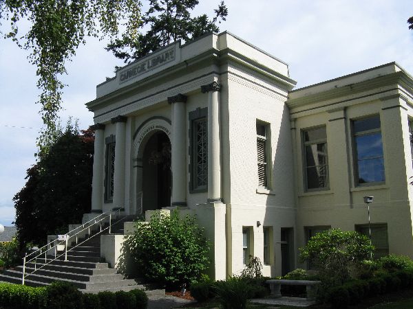
Causland Park (above), Canegie Library (below)
 It seems that some of
today's quaintest towns had boom years in the late 1800's,
then quick busts, and then were forgotten for a century. Anacortes had a similar
pattern. One of the cities founder's, Amos Bowman, dream for
Anacortes was for it to become the terminus of the transcontinental railroad.
This created a year long boom in 1890. Later in the year the Fidalgo City and
Anacortes Electric Railway went bankrupt and the town emptied. The economy
reverted to
It seems that some of
today's quaintest towns had boom years in the late 1800's,
then quick busts, and then were forgotten for a century. Anacortes had a similar
pattern. One of the cities founder's, Amos Bowman, dream for
Anacortes was for it to become the terminus of the transcontinental railroad.
This created a year long boom in 1890. Later in the year the Fidalgo City and
Anacortes Electric Railway went bankrupt and the town emptied. The economy
reverted to lumber and fisheries, which kept the town going but was not
sufficient to simulate redevelopment of developed property. As a
consequence it was pretty much unchanged for a century when its craftsmanship and
historical quality could be appreciated. There remain a few fine buildings
on Commercial Street and a variety of elegant Victorian houses in the
surrounding residential district.
lumber and fisheries, which kept the town going but was not
sufficient to simulate redevelopment of developed property. As a
consequence it was pretty much unchanged for a century when its craftsmanship and
historical quality could be appreciated. There remain a few fine buildings
on Commercial Street and a variety of elegant Victorian houses in the
surrounding residential district.


Washington Park, Anacortes
 A
couple of late afternoon scenes from picturesque Washington Park, near the ferry
dock west of Anacortes. The park must have a pretty healthy and
self-confident deer population
because there were several out grazing during our quick ride through the woods.
A
couple of late afternoon scenes from picturesque Washington Park, near the ferry
dock west of Anacortes. The park must have a pretty healthy and
self-confident deer population
because there were several out grazing during our quick ride through the woods.
Sailing through the San Juan Islands
 overhead. The
color and the texture of the water change with the depth, currents and surface
breeze. It probably can never be the same configuration twice, so the show
is always new. The cultured cyclists would note that this visual
environment clearly was
not the inspiration for Roy Lichtenstein (right) or Andy Warhol
paintings.
overhead. The
color and the texture of the water change with the depth, currents and surface
breeze. It probably can never be the same configuration twice, so the show
is always new. The cultured cyclists would note that this visual
environment clearly was
not the inspiration for Roy Lichtenstein (right) or Andy Warhol
paintings.
Washington State Ferry at Lopez Island terminal.
 The
ferry comes from the mainland to Lopez Island dock about a half-dozen times a day.
Often only zero to ten vehicle drive off. The 'mote-effect" and the time and cost
of getting a car to island do a nice job on keeping a lid on cancerous
motorization of the islands, but still their numbers are growing and the
experience keeps getting incrementally less idyllic. Ironically, one of the
problems with vehicles can be the large number of empty vans plying the roads
for high-carbon foot-print, vehicle- supported, bicycle tours.
The
ferry comes from the mainland to Lopez Island dock about a half-dozen times a day.
Often only zero to ten vehicle drive off. The 'mote-effect" and the time and cost
of getting a car to island do a nice job on keeping a lid on cancerous
motorization of the islands, but still their numbers are growing and the
experience keeps getting incrementally less idyllic. Ironically, one of the
problems with vehicles can be the large number of empty vans plying the roads
for high-carbon foot-print, vehicle- supported, bicycle tours.
Disembarking ferry

"Smart Bike" sign.
What does it mean?
 Instead of "Bike Routes",
on Lopez
Island they have signs for "Smart Bike." May be it is a model they picked
up from the transportation department in Lake Woebegone. Even being
familiar with variations in bike route design, and having ridden a good distance
following the "Smart Bike" route, I am still not sure what it is trying to
convey. The traffic volume was relatively low but that is true of every road on the
Instead of "Bike Routes",
on Lopez
Island they have signs for "Smart Bike." May be it is a model they picked
up from the transportation department in Lake Woebegone. Even being
familiar with variations in bike route design, and having ridden a good distance
following the "Smart Bike" route, I am still not sure what it is trying to
convey. The traffic volume was relatively low but that is true of every road on the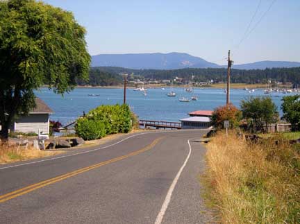 island, there were hills so it is not signage for a flat route, there are gaps in the
signage so it is not a complete system and it doesn't seem to have any
distinctive theme or destinations. What does it mean? In any case,
it out smarted me.
island, there were hills so it is not signage for a flat route, there are gaps in the
signage so it is not a complete system and it doesn't seem to have any
distinctive theme or destinations. What does it mean? In any case,
it out smarted me.
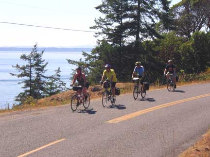
 Lopez Island
is considered the flattest of the major islands in the San Juan Island group,
but don't tell anyone it is flat! Both the north and east sides of the
islands have some contour. Nothing very long, so nothing very high but
there are some short steep sections that will have you
reaching for the gear shift. Mostly Lopez Island is an idyllic mix of
forest and farmland. Most of the traffic we saw was vehicles from the big
"Put-your-bike-on-the-van-tour" company. It is a bit of a mystery why they
need to do that much motoring about on a island, the bulk of which is 12 miles
by 3 miles.
Lopez Island
is considered the flattest of the major islands in the San Juan Island group,
but don't tell anyone it is flat! Both the north and east sides of the
islands have some contour. Nothing very long, so nothing very high but
there are some short steep sections that will have you
reaching for the gear shift. Mostly Lopez Island is an idyllic mix of
forest and farmland. Most of the traffic we saw was vehicles from the big
"Put-your-bike-on-the-van-tour" company. It is a bit of a mystery why they
need to do that much motoring about on a island, the bulk of which is 12 miles
by 3 miles.
.jpg) Above
the door on this Lopez Island barn (left) is a bit of
bicycle art (right). It is amazing how intriguing bicycles look just about
wherever they are and whatever covers them.
Above
the door on this Lopez Island barn (left) is a bit of
bicycle art (right). It is amazing how intriguing bicycles look just about
wherever they are and whatever covers them.
Mt Baker in the background
 Sailing through the San
Juan Islands, Mt Baker frequently provides a photogenic backdrop. For
mainlanders, Mt Baker is a comforting landmark, visible from many places in the
San Juan Islands, the Canadian Gulf Islands and from the southeast Vancouver
Island. It is elegant in itself but perhaps it is also represents
reassurance that the main land is still out there and we aren't slipping off the
edge of the earth.
Sailing through the San
Juan Islands, Mt Baker frequently provides a photogenic backdrop. For
mainlanders, Mt Baker is a comforting landmark, visible from many places in the
San Juan Islands, the Canadian Gulf Islands and from the southeast Vancouver
Island. It is elegant in itself but perhaps it is also represents
reassurance that the main land is still out there and we aren't slipping off the
edge of the earth.
Friday Harbor, San Juan Island
 A logical next stop, on an
island hopping odyssey, is Friday Harbor, San Juan
Island -- an increasingly "boutique village". It has boutique hotel, boutique bakeries,
boutique shops, boutique galleries, boutique restaurants ... you get the
pictures. The arts and crafts in the galleries definitely have the gentle
island feel and theme to them -- no Lichtenstein's here!
A logical next stop, on an
island hopping odyssey, is Friday Harbor, San Juan
Island -- an increasingly "boutique village". It has boutique hotel, boutique bakeries,
boutique shops, boutique galleries, boutique restaurants ... you get the
pictures. The arts and crafts in the galleries definitely have the gentle
island feel and theme to them -- no Lichtenstein's here! 

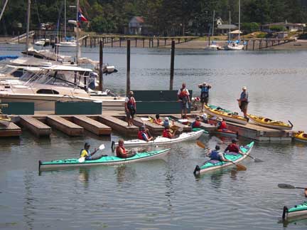 A
nice diversion from bicycling, and a chance to workout some other muscle groups,
like the upper body,
is a sea kayak trip. They can require a little adjustment for each clients
(left), but eventually every is set and pulling out (right).
A
nice diversion from bicycling, and a chance to workout some other muscle groups,
like the upper body,
is a sea kayak trip. They can require a little adjustment for each clients
(left), but eventually every is set and pulling out (right).

View from "Whale Watch Road"
 Westside
Road, San Juan Island, is often referred to as "Whale Watch Road". Even
when the orcas aren't frolicking off shore it is a beautiful ride. When
the whales are in the area it is a real treat. They rarely move on very
fast so you can watch at your leisure. Unfortunately, the population of
whales is decreasing as the quality of their habitat decreases so there are
increasing fewer to see.
Westside
Road, San Juan Island, is often referred to as "Whale Watch Road". Even
when the orcas aren't frolicking off shore it is a beautiful ride. When
the whales are in the area it is a real treat. They rarely move on very
fast so you can watch at your leisure. Unfortunately, the population of
whales is decreasing as the quality of their habitat decreases so there are
increasing fewer to see.The interior of the island also offers very rewarding bicycling with generally low traffic volumes and plenty of pastoral and bucolic views.


 After a busy day kayaking,
circumnavigating the island and taking in the scene, we relaxed for dinner at a
roof top restaurant overlooking Friday
Harbor marina and docks (left). It is also worth check to see if there are
any programs at the San Juan Theater. We happened upon a Beatles revival
show that had the audience dancing in the aisles (right) -- "All you need is
love, love, love is all you need."
After a busy day kayaking,
circumnavigating the island and taking in the scene, we relaxed for dinner at a
roof top restaurant overlooking Friday
Harbor marina and docks (left). It is also worth check to see if there are
any programs at the San Juan Theater. We happened upon a Beatles revival
show that had the audience dancing in the aisles (right) -- "All you need is
love, love, love is all you need."
![]()
![]()


 Please
contact us if you would like to be added to
Ibike's mailing list or have questions, comments, corrections or criticism. (Also, please let us know how you learned about us and
found this site.) Privacy policy.
Please
contact us if you would like to be added to
Ibike's mailing list or have questions, comments, corrections or criticism. (Also, please let us know how you learned about us and
found this site.) Privacy policy.
![]() IBF Homepage
IBF Homepage ![]() Ibike Programs
Ibike Programs
![]() Ibike Schedule
Ibike Schedule
![]() Search
Search